South Florida Seagrass Monitoring
SERL has been monitoring seagrasses at permanent monitoring stations across the coastal waters of South Florida since 1996 as part of the seagrass monitoring program for the Florida Keys National Marine Sanctuary. We also monitor seagrasses in Florida Bay (part of Everglades National Park) in collaboration with the Florida Coastal Everglades Long-Term Ecological Research program. SERL also monitors seagrasses in partnership with Dry Tortugas National Park.
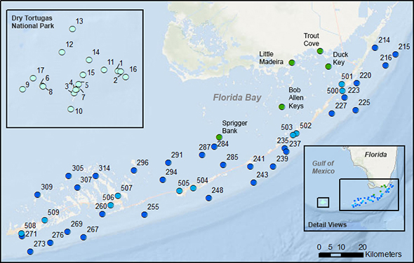
 Florida Bay sites (2002-present) Florida Bay sites (2002-present)
Part of the Florida Coastal Everglades Long-Term Ecological Research Program Funded by the National Science Foundation  |
 Florida Keys offshore sites (1996-present) Florida Keys offshore sites (1996-present)
 Florida Keys nearshore sites (2012-present) Florida Keys nearshore sites (2012-present)
Part of the Florida Keys National Marine Sanctuary Water Quality Protection Program Funded by the United States Environmental Protection Agency 
and by the National Oceanic and Atmospheric Administration  |
 Dry Tortugas sites (2011-present) Dry Tortugas sites (2011-present)
Funded by the National Park Service  |
Everglades NP (Florida Bay):
SB BA LM TC DK
FKNMS:
214 215 216 220 223 225 227 235 237 239 241 243 248 255 260 267 269 271 273 276 284 285 287 291 294 296 305 307 309 314 500 501 502 503 504 505 506 507 508 509
Dry Tortugas NP:
DRTO01 DRTO02 DRTO03 DRTO04 DRTO05 DRTO06 DRTO07 DRTO08 DRTO09 DRTO10 DRTO11 DRTO12 DRTO13 DRTO14 DRTO15 DRTO16 DRTO17
Downloadable datasets are available on our Data page.
Braun-Blanquet Survey Methods
Productivity Methods